Infested Waters Map: When it comes to flight planning, especially for seaplane pilots or operators landing on water, knowing about infested waters is a total game changer. An infested waters map is a detailed, state-by-state database that shows exactly which lakes, rivers, and other waterbodies are infected with aquatic invasive species (AIS) like zebra mussels or quagga mussels. These invasives can wreck ecosystems, clog engines, and cause serious environmental and financial damage. Whether you’re a seaplane pilot, flight planner, or environmental professional, this information isn’t just useful — it’s essential. It helps prevent the spread of invasive species that destroy vital waterways and ensures compliance with federal and state regulations.
Table of Contents
Infested Waters Map
For anyone flying seaplanes or executing flight plans involving water landings across U.S. waterways, leveraging infested waters maps is indispensable. These databases empower pilots to avoid spreading destructive species, maintain regulatory compliance, protect valuable ecosystems, and ensure safer flights. More than a convenience, they are a frontline tool in guarding America’s aquatic heritage, preventing millions in damage, and enabling responsible aviation. Stay informed, follow best practices, and be a steward of the skies and lakes alike.
| Aspect | Details |
|---|---|
| Purpose | Maps showing waterbodies infested with invasive aquatic species. |
| Target Audience | Seaplane pilots, flight planners, environmental agencies, boaters, government regulators. |
| Data Organization | State-level databases with downloadable GIS data and interactive maps. |
| Common Invasive Species | Zebra mussels, quagga mussels, Eurasian watermilfoil, hydrilla. |
| Major Data Sources | U.S. Fish & Wildlife Service, State DNRs, National Invasive Species Information Center. |
| Regulatory Requirements | Mandatory inspections, cleaning, and reporting vary per state but are crucial. |
| Pilot Best Practices | Avoid infested waters; thorough cleaning protocols; pre-flight checks; real-time data use. |
| Official Website | U.S. Fish and Wildlife Service AIS Info |
Why Infested Waters Map Matter for Flight Planning?
Aquatic invasive species hitch rides on boats, equipment, and yes—even seaplanes. When a seaplane lands on an infected lake and then flies to a clean one, it risks spreading these harmful organisms. This isn’t just bad for ecosystems — it can also bring heavy fines for pilots or operators who don’t follow the rules.
Flight planning incorporating infested waters maps helps maintain ecological balance and avoid costly damage. Here’s why it should matter to every pilot:
- Protecting Ecosystems: Aquatic invasives like zebra mussels drastically change water chemistry, compete with native species, and reduce biodiversity. This ecological imbalance threatens fish populations and riparian habitats.
- Reducing Financial Loss: These species clog water intakes on floats and engines, increasing maintenance costs for aircraft. In some states, failing to comply with invasive species regulations can result in fines and operational restrictions, leading to lost revenue for commercial operators.
- Legal Compliance: Federal and many state authorities require pilots landing on waterbodies to check if those waters are infested, follow decontaminating protocols, or avoid those waters altogether if strictly regulated. Violations may lead to enforcement actions.
- Safe Flight Operations: Infested waters can cause unexpected hazards such as vegetation mats or aquatic debris that threaten safe takeoffs and landings.
By factoring in infested waters data, pilots can plan safer, more environmentally responsible routes and protect their aircraft from hidden damage.
What Exactly Is an Infested Waters Map?
An infested waters map is a geospatial tool that charts the locations of waterbodies across states known to harbor aquatic invasive species such as zebra mussels, quagga mussels, Eurasian watermilfoil, and hydrilla. These species cause significant ecological and operational challenges:
- Ecological Harm: AIS displace native aquatic plants and animals, lead to loss of biodiversity, increase algae blooms due to nutrient cycling disruption, and degrade water quality. This affects commercial fishing, recreational activities, and drinking water.
- Operational Impact: Seaplanes and boats can bring these species onboard or in their bilge water, transporting them unknowingly to other waterbodies. Once established, invasives are hard and costly to eradicate.
States maintain regularly updated databases or interactive online dashboards, especially during boating seasons, which identify infested and clean waterbodies, enabling pilots and operators to adapt their route plans accordingly.
Multiple Formats and Accessibility
These maps and data sets are available as:
- Interactive web dashboards showing real-time or near-real-time infestation status.
- Downloadable GIS files for integration into flight planning software.
- Mobile apps like the Seaplane Pilots Association’s Water Landing Directory, which integrates infestation status with airport and lake information.
Why Pilots Should Care?
Seaplane pilots and flight planners must care deeply about AIS because they operate across hundreds of lakes and rivers, often crossing state and even national boundaries. Without proper vigilance, they inadvertently become vectors for invasives.
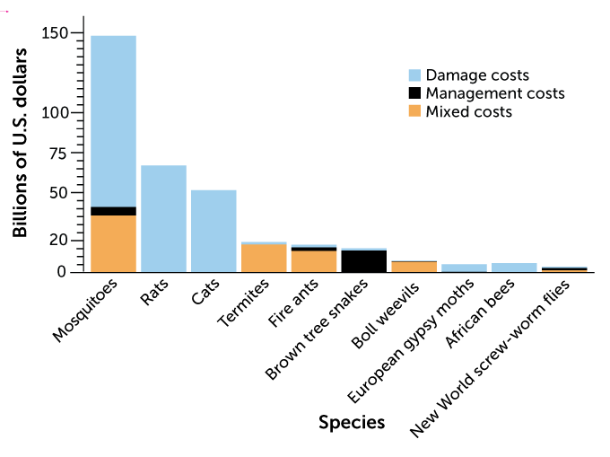
- Environmental and Economic Fallout: Infested waters disrupt local economies by reducing fish stocks, discouraging tourism, and increasing maintenance costs. The US spends hundreds of millions annually combating AIS.
- Operational Safety Risks: Dense mats of invasive plants and accumulating mussels can damage floats and impair takeoff or landing performance, increasing accident risk.
- Regulatory Expectations: Many states now mandate notification and decontamination for pilots landing in infested waters. Failure to follow these rules could lead to penalties, certification suspensions, or operational bans.
Being informed via infested waters maps helps pilots avoid these risks and supports responsible aviation that protects America’s natural resources.
How to Use Infested Waters Map Databases for Flight Planning: A Step-by-Step Guide
Step 1: Find the Right Official Resources
Start at official state and federal websites. Departments of Natural Resources (DNRs) often have data portals detailing current aquatic invasions. The National Invasive Species Information Center is a comprehensive starting point for nationwide data.
Step 2: Identify Infested Waterbodies Using GIS and Dashboards
Use the latest interactive maps or GIS files to locate infested lakes or rivers. Many states provide live updates, highlighting lakes as “Open,” “Closed,” or “Restricted,” indicating regulatory status for landing or boating.
Step 3: Integrate Data into Flight Planning Software
If you use digital flight planning software or apps, integrate these GIS layers to overlay infestation data onto your route maps. Apps like the Seaplane Pilots Association’s Water Landing Directory provide this capability along with additional info on fuel availability, seaplane events, and regulations.
Step 4: Adjust Flight Paths and Landings Accordingly
Avoid infested waters when possible. If you must land on an infested lake, plan for exhaustive decontamination before your next landing, following BMPs published by the Aquatic Nuisance Species Task Force.
Step 5: Follow Up-to-Date Regulations and Notices
FAA and state aviation departments publish Notice to Airmen (NOTAMs) to alert pilots of current flight restrictions including those related to invasive species areas. Always review these prior to flights, as rules can change frequently.
Understanding Aquatic Invasive Species (AIS)
Some of the most critical AIS for flight planners to identify include:
- Zebra Mussels (Dreissena polymorpha): Small, finger-nail sized shells that attach to almost any hard surface, grow rapidly, and clog water intakes impacting seaplane floats and engines.
- Quagga Mussels: Similar to zebra mussels but able to survive in colder, deeper waters, expanding infestation risks.
- Eurasian Watermilfoil: An invasive submerged aquatic plant that forms thick mats, entangling floats and disrupting landing zones.
- Hydrilla: Known as a “super weed,” it grows densely underwater, blocking waterways and increasing drag on flying boats.
All of these invasives severely affect water quality and habitat, requiring pilots’ awareness to reduce spread opportunities.
Real-Life Example: Minnesota’s AIS Explorer Tool
Minnesota has pioneered in AIS management with its AIS Explorer, an online dashboard offering real-time infestation tracking and watercraft movement data. Pilots use this:
- To pre-check lake status.
- Obtain mandatory cleaning condition alerts.
- Access detailed regulations per waterbody.
This modern tool exemplifies how integrating invasive species information into aviation planning can be efficient and compliance-friendly.
The Regulatory Landscape for Flight and Infested Waters in 2025
Regulations have gotten tighter and more complex as scientific evidence grows:
- Flight Restrictions are increasingly common over highly sensitive waters.
- From 2025, new FAA and state rules require pilots to obtain authorization and file detailed flight plans for landings in restricted areas to prevent AIS spread.
- Many states impose inspection and decontamination mandates before flying from an infested waterbody to another.
- Failure to comply can lead to penalties including fines, suspension of flight privileges, or revocation of licenses.
- Restriction updates are often issued via NOTAMs, requiring pilots to regularly check advisories.
- Military, rescue, and emergency flights may have special exemptions but require coordination.
This evolving landscape demands ongoing pilot education and adherence to regulations to ensure both safety and environmental protection.
Additional Tips for Pilots: Protecting Waters and Avoiding Liability
- Always carry a decontamination kit tailored for aquatic invasive species prevention.
- Utilize designated cleaning stations at airports or public boat launches whenever possible.
- Maintain thorough records of cleaning procedures—critical especially for commercial operators.
- Actively report any new invasive sightings to local or federal authorities to support rapid response measures.
- Provide crew and passenger briefings about AIS risks and the importance of compliance.
- Consider joining pilot associations that offer access to updated AIS tools, shared resources, and training.
Why Partnerships and Education Matter?
AIS management is a multi-agency, multi-stakeholder effort involving federal, state, tribal, and community groups. Effective collaboration results in:
- Improved data sharing and systematic monitoring.
- Coordinated rapid response to new invasions.
- Development and adoption of innovative mitigation technologies.
- Habitat restoration and public awareness campaigns that include aviators alongside boaters and anglers.
The Department of the Interior’s Invasive Species Strategic Plan (2021-2025) emphasizes partnerships, accountability, and science-based policy to reduce AIS risks nationwide. Pilots are a vital part of this network.
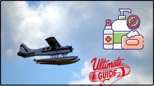
Beyond the Boat: Why Seaplane-Specific Decontamination Is Different
The Ultimate “Clean Drain Dry” Guide for Seaplane Pilots
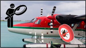
State-by-State AIS Regulations: A Seaplane Pilot’s Compliance Guide